Other Studies & Plans
The MPO has created many other plans and studies over the years to better guide how we use our limited resources – time and money. The plans and studies identified below focus on specific areas or corridors (roads) in our area. All of these documents have been completed within the last 5 years. These guiding plans and studies continue shaping conversations and are helping us implement improvements across the Lexington area. For those interested in older efforts and more historical context, check out our archive.

East Lexington Trail Study (2022)
The goal of this project is to continue the city’s efforts to create a trail network across Lexington. Ensuring safe and comfortable options for bicycling and walking will help ease congestion, enhance public health, support local business, and improve the air we breathe.
This project kicked-off with a public input survey in the spring of 2022. Using community feedback and site analysis, the project team determined the best route for a connection between the Brighton Trail and downtown Lexington along Liberty Road. Specific features and design of the new trail and roadway come from analysis of public comment, existing development, and other local resources.

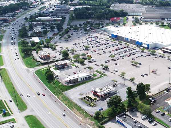
Imagine Nicholasville Road was adopted as a part of the city’s comprehensive plan, Imagine Lexington, on May 20, 2021.
After over a year of study, data collection, and public input, imagine Nicholasville Road articulates a vision for one of Lexington’s most important corridors. This plan focuses on safety and efficiency for people traveling by car, bus, bike, or on foot. The recommendations are tailored to the unique areas along Nicholasville Road and include:
- Innovative intersection improvements
- Plans for Bus Rapid Transit
- Future redevelopment of large parking lots and underutilized shopping centers
- Dedicated bike and pedestrian facilities
- A lot more!

Versailles Road is one of Lexington’s major arterial roadways connecting the City of Versailles and the Blue Grass Parkway to downtown Lexington. Due to conditions and increased demand for high quality pedestrian and bicycle facilities, the Lexington-Fayette Urban County Government initiated an in-depth study. The Versailles Road Corridor Study, completed in 2015, is a comprehensive analysis of approximately 2.5 miles of Versailles Road (from Parkers Mill Road to Oliver Lewis Way).

The primary purpose of the Lexington Area Bottleneck Management study was to:
- Identify roadway bottlenecks,
- Evaluate their conditions,
- Rank the bottlenecks,
- Propose relief improvements, and
- Provide preliminary engineering cost estimates for each of the proposed improvements.
A steering committee included Lexington MPO staff, the Kentucky Transportation Cabinet (KYTC) Planning / District 7, and LFUCG Traffic Engineering / Engineering Divisions.

The Kentucky Transportation Cabinet (KYTC) and the Lexington-Fayette Urban County Government (LFUCG) initiated the Hamburg I-75 Crossing Feasibility Study. The purpose was to evaluate potential options for increasing connectivity over or under I-75 between Sir Barton Way and Polo Club Boulevard. The study examined possible connections which KYTC and LFUCG can use for programming project dollars and to better inform future land use.

The Kentucky Division of the Federal Highway Administration (FHWA) and Region VI of the Federal Transit Administration (FTA) conducted a certification review of the Lexington Area MPO in 2019. The primary purpose of this regular review is to formally evaluate the planning work we do here in the Lexington area. We exceed the population minimum (200,000) that requires this standard review. This Federal oversight ensures we follow procedures, but it also makes recommendations for improving the effectiveness of the MPO.
Lextran conducted a study of its existing assets, covering things like vehicles, equipment, facilities, and operations. Lextran set performance measures and targets in this 2018 Transit Asset Management Plan.

The Lextran Coordinated Public Transit-Human Services Transportation Plan is about coordinating transit so older adults and people who have disabilities can get around. It looks at the transportation needs of these groups of people and describes ways to ensure these needs are met. The plan is important for deciding how money will get spent on these services.
The plan is required by the Fixing American’s Surface Transportation Act (FAST Act). The FAST Act says that every state must have a plan for helping older adults and people with disabilities get the transportation they need. The plan must show how money from the Federal Transit Administration (FTA) will be used to accomplish this.

“Intelligent Transportation Systems” (ITS) are communication technologies that monitor congestion and respond in real time to improve traffic flow and safety, especially during peak travel periods.

The purpose of the Downtown Lexington Traffic Movement and Revitalization Study was to provide a structured, systematic process for evaluating the conversion of one-way streets to two-way and to provide information to decision makers regarding the impacts and mitigation of these conversions.

Looking for more? Want to dig deeper? Curious about our older work? You can explore our past studies and plans in our archive. If you have questions or comments, please email lexareampo@lexingtonky.gov.
